Monday, January 01, 2007

How to find our photos


How to find us...
Originally uploaded by Henrik & Barbara.
Hi friends and family
If you want to see the rest of our photos from our days in Brazil, our South America trip and our life in Japan starting 1st of February, please send us an email and we will give you access.
Sorry for the inconvinience, but we found it nessecery since our pictures started to show up on strange places on the internet.

Looking forward to hear from you!

:-)
Henrik and Barbara

Thursday, December 14, 2006

Reaching the end...


Climbing the glaciar.
Originally uploaded by Henrik & Barbara.
Our last stop before heading towards Asia was the Perito Moreno Glaciar.

Thursday, November 16, 2006

Still Smiling!

Just a short message to you all saying that silence can be good thing.

We are right now in Buenos Aires, and what a great place to be!
We are enjoying the modern city life, the great food and wine, and the wonderful spring climate...30 degrees.

The plan is to leave for The Iguazu Waterfall this weekend. Next week we will fly to El Cafayete. Main reason: The Moreno Glaicer and The Chaltén.

We have decided to get the best out of the last couple of weeks of vacation, meaning we will spend less time in front of the pc.... That means that this will be the last message on the blog until we are back in dk.

It looks like we will arrive in dk the 14. th of December.

We are looking forward to see you all again!
The best to all of you.

Hugs and Kisses
Henrik and Barbara

P.S. As we will spend less time at the Internet cafés - we will probably get sloppy answering any emails from you guys until we are back in dk.

Thursday, November 09, 2006

Sucre - in between dinos and weavers


Patience.
Originally uploaded by Henrik & Barbara.
Red is for the blood shed from the many heroes that fought for the Bolivian independence. Yellow is for the country’s richness in minerals. Green is for the nature.
As Sucre is the official capital in Bolivia it makes sense that this was the place where we figured out why the Bolivian flag is bearing its colours.

We figured it out, wandering around the Casa Libertad, a colonial building dedicated to Bolivia’s struggle for independence and where until today – the government constitutes every year.
The place ooze with details from the Bolivian history, from antique maps showing the borders of Bolivia as they used to be (with coastline!), blood stained flags from the battlefields, the many wander sticks of the different presidents, ashes of the most famous female warrior, weapons, a copy of the independence contract and portraits of all the 66 different presidents that Bolivia have had in their relatively short period of democracy – a fact that actually have given Bolivia a place in the Guinness book of records: The country with the greatest amount of presidents in shortest time! Nr. 66, Evo Morales is the first indigenous president ever, making him a quite special finale so far. Other interesting president facts, was that Bolivia’s first president was from Venezuala, and that Bolivia for a short period had a female president. Women in Bolivia did have courage! One of the most spectacular Bolivian warriors was a woman. She participated in more than 20 important battles.
A good friend of ours told the story of many women, old people and children that defended the Cochabamba region, whilst their men had been called out to fight battles further away. The women did not just sit with their hands in their laps.

Here we also discovered why all the Indians are wearing knee short wide skirts: Fashion! The Spanish queen used to wear it during the colonization and it sticks until this day.

The region around Sucre is famous for its weavings. ASUR (a local NGO) have since the mid 80íes successfully been working with the local communities with the aim to preserve the local tradition of weaving. They have established a combination of a museum, work shop and shop. It’s an adorable place where we got a good understanding of the work and the art. The level of detail is stunning and we ended up buying a piece of their weaving for the wall - a genuine piece of art.

Sucre “The white city of South America” was an interesting experience, - also from an architectonical point of view: The centre of the city only consists of white buildings, and local law requires a yearly cleaning of the buildings to keep them white.

We also went to the Carl Orko. A huge area full of dinosaurs! Well…the dinosaurs are full sized plastic sculptures – but never the less, with a good imagination you could easily picture them alive…. Well… maybe we have seen Jurassic park too many times.
Carl Orko is the world’s biggest known collection of dinosaur footprints. Within an area of 1.5 km x 150m, more than 5000 prints from at least 150 different dinosaurs can be seen.
Unfortunately, we were not allowed to come really close to the foot prints – but standing 100 meters from the huge wall with rows of giant million year old footprints can be a pretty amazing view anyway!
Until this day; the owners continue to discover new foot prints. Last month they found 600 “new” foot prints.

After Sucre we went on to Santa Cruz.

Thursday, November 02, 2006

Potosí - “The highest city in the World”.

At 4100 meters above sea level, that is what they call Potosí here in Bolivia. Maybe there is a small town in Tibet that can compete with this honour, but it is certainly not a city of the size as Potosí.

So, why build a huge city in 4100 meters where nothing can grow and where you won’t find a single tree near the city, meaning that almost everything has to be transported from remote locations? - The answer is silver!
Potosí was one of the richest cities in the world when the silver mining was at its peak, with more than 6000 active mines. The mines are still active today, but the production is reduced to almost nothing compared to the past. The history of the mining is brutal. An estimate of 8 million people has died in the mines because of the poor working conditions. The working conditions today haven’t changed much and counts children and woman in the staff as well.

Potosí is an interesting city, which shows evidence of the rich colonial era with the Royal Mint and the many churches.
The Royal Mint used to be the biggest of its kind in South America and it is a huge building (7500 square meters) that now contains an impressive museum with colonial and indigenous religious paintings, besides the equipment used to melt the silver and produce the coins.
The indigenous paintings are interesting because they combine the catholic symbolism and the original indigenous symbols, as the sun, moon, stars and Mother Earth ‘Pacha Mama’ together with the catholic virgin. The Spaniards chose to accept this combination – a small price for them to convert the indigenous people to Christianity.

The guidebooks describes Potosí as a city in sorrow, because of the cruel history. But instead of finding a mourning city, we found a very lively city with young happy and energetic people all over the centre of the city. An energy that were very surprising, maybe because of the expectations we had. We loved walking down the streets, surrounded by this positive energy.

Another kind of energy that surprised us, was when we went into a restaurant which was described as an upmarket French-Bolivian restaurant. Apparently the restaurant changes character to a Peña at Saturdays afternoons. A Peña is a kind of folk music bar, and in this case it meant a place-where-you-get-totally-drunk-until-you-fall-asleep-place…We enjoyed the local live pan-music and ate in a maybe-we-don’t-belong-here-speed, and left the locals (all male) with their Singani and beers alone…

From Potosí, we continued east and down towards the official capital ‘Sucre’.

Bus experience

The old grasshopper was ready to consume us. That was the thought going through our minds, when we found our bus at the station in Uyuni: A small (20 seat) green and yellow thing with curly antennas looking like feelers and red lights making it out for the eyes…

We were heading for Potosi and 6 hours suddenly felt like a long ride as we squeezed into the out-of-order-almost-and-therefore-almost-horizontal-leaned seats leaving absolutely no room for our European legs. The real charm was the fact that the whole trip is on dirt road!

The driver was not in a hurry. He took his time stopping whenever a local was standing in the side of the road asking for a ride. Soon the aisle was crowded with people sitting on the floor.
The road too was crowded – with llamas...in huge flocks they were scattered around near the small water pools we passed on the way. They couldn’t really bother less about the bus, and a big hunk from the driver was necessary to keep us going.
Despite the water pools, the landscape seemed hostile and ungrateful. Not much vegetation and we wondered were all the Bolivians are living, not passing any houses for ages.

Our real favourite moment though is bound to be when the bus broke down… or to put it more precisely: the crank shaft fell of. The drivers went out to take a look, with all the passengers still locked in. After ten minutes, the driver locked us out and we knew this could take a while…
Impressed by the drivers mechanical skills we sat down and watched the show, in the middle of nowhere with the sun burning. It was first when they started to use a hammer, Henrik got worried, but actually that was when they succeeded in fitting the shaft back again.

The rest of the trip went smoothly and we ended up being only 1,5 hours late...

The colours of Bolivia

(Continued from day 3)

5 o’clock in the morning we got up, to see the sun rise at the geysers named ‘Sol de Mañana’. Without knowing what to expect, we were quite surprised that we arrived at a landscape equal to Mars (again!). This time it was even more unearthly
than at the volcano Tunupa, with numerous geysers shooting high-pressure jet of steam out from the earth, surrounded by countless boiling pools of mud and sulphur in several colours intensified by the beauty of the sun rise. The only downside was the intense smell of rotten eggs, caused by the sulphur coming from the underground… :-)

Continuing south towards the Chilean border in almost 5000 meters above sea level we passed a desert landscape with colourful volcanoes and some spectacular rock formations half covered in volcano dust called the “Dali rocks” inspired by one of Salvador Dali’s paintings.

The last scheduled stop before the Chilean border was at the volcano Licancabur and Laguna Verde (The green lake). This volcano marks the border between Chile and Bolivia, and has been used as playground for NASA’s Mars-vehicles… (This was our last meeting with Mars on the trip).
At the foot of the volcano lays the green lake, which has a deep green colour from the algae in the water.
At the Chilean border we parted with the Swede, without tears…because it left more space in the jeep for our 390 km. journey back to Uyuni - on dirt road.

Having expected just a long boring ride back to Uyuni, we were positively surprised by the encounter of a Bolivian ostrich the ‘Ñandú’ who must have inspired the Road Runner cartoon, from the dust stirred up behind it as it galloped away from the car “BEEP, BEEP!”
We also encountered the Bolivian hare ‘Vizcacha’ jumping acrobatically in another bunch of gigantic lava rocks, where only the imagination could set limits for the variety of animals and figures that the rocks formed. We saw both a lion eating its prey and a huge pelican guarding the place…besides the livelier vizcacha.

The driver thought we had time for another extra, so he squeezed in a stop at the deep ‘Cañon de Cascadas’ ( Canyon of the waterfalls). It looked most of all like one of Gaudis creations combined with the imagination of Mother Nature with the twisting and sparkling river in the bottom of the canyon.

The last (unscheduled) stop was in San Cristobàl which is a 5 year old indigenous village which has been constructed by a mining company that forced all the inhabitants to move from their original town at the newly discovered mining site. It seems quite brutal to force a whole community to move from the home, but after 5 years the mining company and the authorities are still doing a lot to help the locals by improving the infrastructure and by promoting tourism in the area, so maybe it will work out for the locals benefit.

Arriving back in Uyuni tired, after no good sleep in four days dirty, after four days with only one shower and loads of dusty dirt roads, we had the feeling that Bolivia must be the place on earth that demonstrates the most spectacular nature within such a small area. Definitely one of our best experiences so far here in South America.

And a nice side effect: We learned that we actually know Spanish by now. After having acted as Spanish-English interpreters for four days, we feel confident in the language… Sometimes it is under those circumstances that you become conscious of you limits and abilities.

(The end.)

Wednesday, November 01, 2006

Thousands of Flamingos

(Continued from day 2)

The half day drive to the Reserva Eduardo Avaroa took us through some wide mountainous landscapes. First stop was at an area covered with large-scale volcanic rock formations. The formations had many different shapes and only the imagination can limit the strange things you see in the rocks. We played around and ended with Barbara in a huge snake’s mouth! The playground also served as a great lookout point to the vaguely smoking Volcano Ollague which is the only active volcano in Bolivia (5865 m. high).

The bumpy ride continued on to a couple of the brackish lakes in the region: Laguna Cañapa and later Laguna Heidona. Both are located surrounded by reddish mountains and have a rich flamingo-life.
Sitting down at the edge of the lakes, embraced by the mountains and the silence you slowly absorb the beautiful look of thousands of flamingos looking for a snack in the blue-white still water. Magic for sure.

Three of the worlds five different kind of flamingos live here: Chilense, Andino and James. How you see which one is which, is by the colour of their tail, their legs and their beaks. From a distance it can be really difficult though to differ one from another.

The volcanoes surely left a lot of foot prints in this region and we made another stop to explore some of them. Again this was big dimension volcanic rocks. This time the rocks were all aligned with a special plant clinched on the sides of them. The plant is a kind of moss, but very hard. As a replacement to ordinary wood, this plant used to be dried and used as fuel for the trains etc. The plant grows several meters tall and gets hundreds years old. The bright green colour made a grand contrast to the reddish volcanic rocks.

In 4700 meters above sea level the landscape turned into a desert. Few yellowish plants scattered around, the reddish dirt, the almost purple mountains were stretched to all sides and once in a while a small flock of vicuñas crossed the road.

Time for the second biggest landmark on the trip: Arbol de Piedra. (The salt lake is bound to be the first). Arbol de Piedra meaning Stone Tree is an eight meter tall rock which balances on a narrow stem. The rock has for many years been carved by the sand and the wind which have ended up given it a form like an abstract Dali-tree. Beautiful – in a weird way.

Last stop that day was Laguna Colorada located at 4000 m. Colorada means colorful and so it was! Most bizarre was the almost blood red water, due to a high level of beta-carotene. Starring out on the blood red water made you realize that everything is possible! Nothing should be assumed.

Laguna Colorada is also the worlds biggest single nesting site for flamingos, meaning that up to 70.000 flamingos are in the lake at one time during the nesting season! Right now it is not the nesting season though, so we only counted around 30-40.000 flamingos nip in the water, flying in small groups, crossing beaks (kiss?) and enjoying the sun.
The white ones we saw, was the babies... Not fed up on beta-carotene yet.

The Laguna Colorada is near the official entrance to the Reserva Eduardo Avaroa where we were going to spend our last day. The sun was going down though so we stopped for the night in a chilled dorm.

(To be continued.)

Monday, October 30, 2006

Enjoying a day on the Salt Lake

(continued from day 1)

Waking up at the foot of volcano Tunupa to see the sun rise over Salar de Uyuni, to see the suns reflections in the motionless water and to see the sun shining at the flamingos and the volcano with its green, red, orange and beige colours was the perfect start on the second day of the 4-day trip.

After an early breakfast we went up the volcano where our first stop was at a primitive but well preserved tomb from the 13th-15th century. The tomb belonged to the Tiwanaku civilization which stretched over a big part of Bolivia before the Incas conquered the region. Inside the small burial chamber made in a cave, several persons (now mummies) were buried together with their most important belongings, so that they could bring them with them into the afterlife. Quite impressive the way the Andean weather can preserve the mummies that well, - even the clothing made of vicuña and guanaco wool is still intact after 500-700 years!

From the tomb we continued further up the volcano from approximately 3800 meters to 4200 meters going almost vertical. This was not exactly what we had expected of a morning stroll, but the final goal with a view over the entire (or almost the entire) salt lake, made us forget the effort of walking up the volcano. So worth it!

The walk it self did have it moments too. We followed a ‘llama path’ which has been made by the locals by building up primitive stonewalls, to prevent the llamas of eating the crops as they are sent grassing in the neighbourhood.
On the way we had a close reencounter with the Andean condor. In contrary to Peru, it came really close to us this time, and it was easy to see its white collar and the spread wing tips. We also passed a small field covered with the native plant Quinoa, which is a type of grain used in soups or as a side dish like rice. It is planted on the mountain side in 3700-4200 meters height. It is not vulnerable to the cold going way below zero, the sun though, can give it a tough time, why the locals need to cover the small spout with dried grass until it reach a height of 10 cm.

From the 4200 meters height, we did not only have a great view of the salt lake, but also to the colourful crater of the volcano Tunupa which is best described as something you would find on Mars, with its intense reddish colours. We snapped in the fresh air. Not really sure it gets more fresh than this?

We squeezed together in the jeep again and went from our lodging at the northern part of the salt lake to the southern part crossing the lake with a short stop at Isla Pescadora (the fisherman island). Here we entered a gigantic frog! (Well, actually it was a cave which looked like a frog, but why worry about the details).
What made the experience most special though, was that we had the place completely to our selves. Our cook and guide picked herbs for tea, Henrik climbed the island as he always hungers for places with the best view and the rest of us enjoyed wandering around on this deserted place feeling relaxed. Looking out at the otherworldly salt lake never seems to bore, it does seem to calm though.

Last stop on the salt lake was at the southern part of the lake where we saw some huge visible salt formations (hexagons). Why hexagons? That’s a question nobody can answer yet, many think it is because of the minerals in the underlying layers.

This was our farewell with the salt lake before we turned further south along the Bolivian highland. For a long while the salt lake continued to be visible in the horizon. The mirage effect of the islands on the salt lake was an unforgettable sight.

On the mainland the first stop was two caves near San Juan. The first cave has been given the name “Galaxies”, because of the futuristic lava formations inside the cave. It was discovered in 2003, so the specialists are still far from having studied its origin. So far the theory is that the cave used to be part of the Uyuni Lake, and because of a combination of ice ages, volcanic eruptions and fossil plants the cave is now like a dry version of an aquarium. It is like no other cave we have ever been to and the name, the Galaxies, makes good sense.

Close to the Galaxies the “Devils cave” is located. The Devils cave used to be a cemetery and it contains many pre-Inca tombs. Unfortunately grave robbers have emptied most of the tombs, leaving only 4 mummies for us to see and compared to the ones we saw near Coqueza we weren’t really impressed. On the top of the caves though, some strange cactus fossils have been placed, which gives an exiting contrast to the surrounding barren landscape.

The long day ended in a very small and dusty but friendly village. Everybody greeted us and were very pleasant and kind, which we have not felt to that extent many places.
Enjoying one of the best beers ever, after having spent a long day on the salt lake and on the dusty roads…well we felt like in heaven.

(to be continued)

Saturday, October 28, 2006

Entering the worlds biggest salt lake - Salar Uyuni


Long legs...
Originally uploaded by Henrik & Barbara.
Uyuni – What the heck is that? You probably wonder, and so did we... Arriving in the city last Sunday we knew that we were going to enter the world’s biggest salt lake, but about the 30.000 flamingos, the blood red lake, the geysers and the huge volcanic rock formations, we had no idea. That was to be discovered in the following days.

Arriving in Uyuni we were immediately surrounded by many of the more than 40 different tour agencies there are to be found in Uyuni. To choose one for our 4-day trip was not an easy thing, but helped by the many advices at the Lonely Planet forum and an excellent ranking system initiated at one of the local bars in Uyuni we came down to Turismo el Desierto. They really deserve to have their name mentioned, since we had an amazing trip with no worries at all. It actually ended up being one of our absolutely highlights for our so far 2 month long trip in SA.

The trip is off road or via bumpy dirt roads, totally 1100 km in four days. A good jeep is therefore essential. One of the common complaints with the tour companies in Uyuni is the state of the jeep. The jeeps have a tendency to be pretty worn out and break down several times during the four days; so it was with a relief that we met our relatively new red jeep.
Everything was loaded, the group, a Brit, a Swede, a Dutch couple and us, was squeezed in together with the cook plus the guide/driver and then the adventure was ready to start.

The four days was very intense with loads of different dreamlike sceneries and great nature-moments and until the last moment of the trip we were caught by surprise by this beauty and variety. To memorize it all is a challenge, having experienced such days. Here is most of what we do remember:

First stop was the train cemetery in the outskirts of Uyuni.
Bolivia has a long history of wealth in minerals and metals and in the1880’es a railroad was built in the Uyuni region to facilitate the transport of the minerals and metals. Steam locomotives were imported from England and it is these 150 year old trains – or rather the left over of them, we now could use as a playground for a few minutes climbing the huge old steam locomotives, getting an insight in the history of the region – because no railroad, no Uyuni, as Uyuni was founded because of the many workers needed for the railroad construction. Many ways interesting, but SO not the highlight of the trip…that came few minutes later, as we entered the magical world of the 12.000 square kilometres of plain salt! The Worlds largest salt lake was one of the most surreal experiences we have had so far. As far as the eye could spot, the ground was sparkling white. The brain kept telling us it was ice or sand. It was simply not believable that this could actually be normal eatable salt! The prove came within minutes when we stopped at the village Colchani where the salt is being treated before it is sold to the rest of the country. The process is 100% manual: After collecting the salt, the locals dry it, mix it with iodine, and in the end pack it for distribution. A simple and cheap process – but of cause they do sell the end product pretty cheap: One kilo of their salt for just 0,50 boliviano (around 0,40 d.kr).

The locals have one other use of the salt. They use it as bricks to build houses, furniture etc. They actually have built hotels where everything from the construction, to the beds, tables and sculptures are made of salt! Pretty amazing, with a sort of magical feel to the white sparkling rooms, but it was way too touristy for us so we skipped a night there. Though we did enjoy a nice “naturally cold” beer (Bolivians exotic way of saying that they don’t have a fridge for their beers) at one of the salt tables finding it all pretty unreal.

Next stop was on the actual salt lake. The salt lake used to be part of a huge lake that covered almost the entire highland of Bolivia. The water in the lake diminished between the five ice ages which has now resulted in the salt lake.
The salt layer is said to be about 10 meters deep today, growing one cm per year due to evaporation processes that transports underground salt deposits up to the surface.

Out of 35 islands in the salt lake, the ‘Isla Inka wasi’ (‘The Inkas home’) is by far the most impressive with its up to 12 meters tall cactuses covering the island. As the cactuses grow 1 cm pr. year, it has been calculated that the oldest cactus on the island is 1200 years old! Standing at the island, looking out, at the stretches of whiteness made you mystified!

After a lunch break at the ‘Isla Inka Wasi’ we went on a “special” tour. Instead of continuing south as most tour groups do, we had our driver convinced that it was a better idea to go to the furthest northern point of the salt lake, where you find the small settlement Coqueza at the foot of the inactive Mars-a-like volcano Tunupa. In that way, we would have an extra day at the salt lake.

Coqueza consist of only 10 families whose main income comes from quinoa and llamas. After having installed at the rather simple chilly rooms we went out to watch the sun go down on the salt lake. Our only company was the flamingos nipping for food only 100 meters away.
The sun set was spectacular. Should you look at the sun setting in one direction, look at the volcano with all its colours, look at the infinity of the salt lake or look at the purple clouds in the last of the four directions; beautiful, beautiful, beautiful.
(To be continued).

Saturday, October 21, 2006

La Paz


Calle Jean - La Paz
Originally uploaded by Henrik & Barbara.
Purple potatoes, black corn, freshly peeled peanuts, dried llama fetus, Alpaca bags, hand-woven llama gloves, amulets for happiness, sacks of rice, dried healing herbs, freshly made orange juice, tons of salteñas and empanadas, white tomatoes and people reading your future in coca leaves. Everything is to be found in this bustling market city where taking a walk in the Aymara neighborhood stimulates all senses.
We have fallen completely in love with the energy of this colorful city and have used several days on foot, observing everything, never getting tired of it.

Since we are heading back to La Paz in 1,5 month we haven’t put much effort in visiting some of the sights in the city. We did though visit the coca museum. We went there, and were greatly surprised. For the first time on our long holiday we found a museum with extensive information in English.
Did you know that The Coca Cola company still are importing tons of coca leaves from South America as they still add the leaves in Coca Cola for the flavor. At the same time the U.S. Government is fighting for a coca free SA. Make sense??? Hmmm…
We also have an idea of the process of making cocaine or how important the coca leaves are for many of the hard working South Americans.

Crossing the Prado (main street) we entered the northern part of the city, meaning we entered the Spanish side of the city. From witches market, indigenous people and colorful market stalls we now found Burger King, men in suits and beautiful colonial buildings. We landed at the main square where Evo Morales live and stopped time for a moment. The guarding soldiers had their shoes polished, the kids were feeding the many pigeons (another universal thing: pigeons on the main square), vendors of ice cream and salteñas where passing by all the time, and every single bench and staircase was filled with a mixture of locals, young and old taking a break from reality – or maybe enjoying their reality.
In many ways this part of the city reminded us of many other large cities in South America and though it was nice, we definitely prefer the more colorful Aymara part La Paz.

We are looking forward to coming back soon and explore La Paz more, but for now we will head to Salar de Uyuni – the biggest Salt Lake in the world.

First taste of Boliva


Fisherman
Originally uploaded by Henrik & Barbara.
It was with great anticipation we went to Bolivia, where our first stop was Copacabana (the original Copacabana...) at Lake Titicaca.
Copacabana is not the “real” Bolivia. It is a city which is clearly affected by the thousands of Bolivian and international tourists who come here on their way to or from Peru to experience the beauty of Lake Titicaca and Isla del Sol or to worship the holy saint Virgin of Copacabana.

We spent two quiet days in Copacabana, where we witnessed the religious significance of the city for the Bolivians, we tried the best trout lasagna in South America and of cause we visited Isla del Sol – the place where the sun is said to be born.

Copacabana has been important since the Incas and are still regarded as the religious centre of Bolivia. The most spectacular prove, is the blessing of cars. They actually decorate cars and trucks in flowers as part of a blessing ceremony which will make sure the vehicles have a safe journey. This takes place in front of the colonial church in Copacabana, which is very impressive and quite different from the other colonial churches we have seen so far with lots of colorful tiles. It demonstrates the great influence of religion in the city and this is where the Virgin of Copacabana is guarded.

The subject food brings us to maybe the best lasagna (trout lasagna) we have ever tried – even compared to classical meat filled lasagnas. The trout and king fish are the two most common fish in Lake Titicaca, and the trout is the specialty of the city which they showed us convincingly in the various forms we tried the fish; in lasagna, with garlic and with lime.

An hour by boat from the shore of Copacabana beach you find Isla del Sol, the place where, according to the Incas, the sun, moon and stars were commanded to rise by the Inca God Viracocha who rose from Lake Titicaca himself. Of cause we had to see the place with our own eyes and spent a whole day there exploring the magnificence of this place. The landscape on and around the island is stunning.
With the fresh air, the blue lake, the snow capped mountains, the terraces and the ruins we were easily convinced that this place must have been extremely important for the Andean cultures in the past and that it will stay important long into the future.
Standing in front of the rock where the sun was born gave us a moment to imagine life there when the Incas ruled. Sacrifices of food, animals and even humans was made to the sun and only selected people could get close to this gigantic holy rock. Thousands of people worshipped the sacred rock.

Friday, October 20, 2006

Visiting Lake Titicaca

Lake Titicaca (Rock of the Puma) is the world's highest lake navigable to large vessels at 3,810 m above sea level between the borders of Peru and Bolivia. With a size of 8,300 km2 and a length of 190 km it is big! The lake is inhabited by several different cultures all taking pride in their own local costumes. They live on either real islands – or islands they have built themselves.

Wanting to explore the life on some of the islands on Lake Titicaca, we arranged a guided tour to two of the different indigenous cultures: The people on Isla de Taquile and the Uros Indians living on homemade floating islands.

Taquile Island is a big island located 35 km from the harbour of Puno. The indigenous people living there, speaks Spanish and Quechua and they have some really weird customs, - we laughed very much having them explained. For example, they have a hat-dress code! If you are a boy under 14 you need to wear one type of hat. If you are more that 14 years old and single you will wear another hat than the ones being married and so on. Also – the way you wear your hat says a lot! Wearing it to the side – you are sad and having some kind of problems. Wearing it to the back you are a happy man! You can change the way you wear your hat/your mood every couple of hours if you feel like it. The rules continue on... being a single girl you will wear big pom poms on your sjale. Being married you need to tone down: meaning you only use little pom poms. Within the first 3 months of engagement you need to move in together with your partner and his family. If you do not get pregnant within 5 years, the engagement will be cancelled. For sure you can not get married without having a kid first! Normally you get 5-8 kids. If you want to be a leader (meaning you are allowed to wear a special hat) you need to have at least three children! How the boys meets the girls? They carry little stones in their pockets. When they see a girl they like, they throw the stones at her!

Enough said about the strange rules. The inhabitants live primary of agriculture and weaving with a technique as old as their history. Of cause the tourism has had a small influence on their life and it is said, that was it not for the tourists the above rules would probably die with time. Despite the little impact tourist do have, the 300 Quechua families seem to be living on Taquile Island still very much following their ancestral customs, which you could feel as you passed by the old man knitting a hat or the small kids leading their group of sheep.

The terrain reminded us the Cusco region. Lots of ancient agricultural terraces and rustic stairs made of rocks. We had a nice walk going up up up, a couple of hours on the main square watching the habitants weave, and after lunch we continued to the Uros Islands.

The Uros islands are like nothing we have ever seen before. If you can see behind the somehow touristic facade, you will feel the magic feel to this place. It’s a place where time hardly seems to have had any influence on the everyday life of the Uros Indians.

When the Incas expanded in South America hundreds of years ago, the Uros indians was forced our of their territory and onto the lake. How to do that not having an Island to go to? Well they took advantage of all the totura reeds growing at the banks of the lake and used them to build everything they needed, first of all islands! By making a 2-3 meter deep island of layers of reeds, they succeeded in building sustainable floating islands. Until today they carry on this tradition. Imagine that! Stepping onto an floating island at first feel like stepping on an waterbed. But as you reach the centre of the island it is impressively stable.
2-3 times per month the locals need to put out a new layer of reeds. Doing that, the island can last for many years.
We had arranged to spend one night living with a local family. This is not normally for the tourists, but for us in was an important way in our seek of going behind the somehow touristic façade.
All in all there are around 45 floating Islands. Originally the islands lived of agriculture, primarily fishing, but after the islands have become more and more famous, many of the islands have chosen to live from tourism meaning that they welcome tour groups to visit their island a couple of hours in the morning, to get a peak into their lifes, in exchange of getting a chance of selling some handicraft. There are still some Uros though who continue on their lifes on islands away from the tourists.

The island we visited is named Khantati and is a family island where everybody is related. The whole family had together made the decision to go into tourism since it pretty much disturbs everybodys private life.
Our host Rita was a kind and open woman and as soon she heard that we were coming, she invited us to a local wedding on one of the other islands. Unfortunantly, we did not make it in time for the wedding so when we arrived at the island, it was nearly deserted except for two women showing us Ritas hut for then to turn to their own huts again.

We had a feeling of having the whole floating island for ourselves. Very strange. A feeling of solitude reached us, in a good way. On the other side we could not help feeling a little abandoned. When would everybody come back from the wedding?
We took a couple of walks around the island (had to be a couple since one walk around the island is only 30 seconds of entertainment). Anyone surprised that Barbara got wet feet, being too curious and not noticing where the island needed repair? Then we went to our hut. It was too made of reeds. Since they don’t have closets their clothes hang on the walls being rather decorative in its strong colors. We checked the madras, it was real! We had expected a reed madras so this was a nice surprise. Returning outside we found one of the women and got into a nice chat with her about life on the floating islands. The kids go to pre-school on one of the neighbouring islands. To go to highschool, they need to go to Puno, about an hour in a small boat. What about problems with neighbours? Well they simply cut the island in two and let their enemy drift away.
In the middle of the conversation Ritas mother showed up with a bunch of kids. She asked if we wanted to join the kids as they were gonna go to the wedding party to pick up all the missing island people.

Sure, why not?! So we went on a ride with the 14 year old Eduardo rowing the boat. As we came closer to the wedding party we began to realise what we were letting us in to. Music, dance and lots of beers, hundreds of happy drunk locals. The way to celebrate weddings is for sure universal. Rita and a couple of her indigenous friends invited us out for a dance. They were wasted and Rita landed on the ground several times. Henriks dance partner, a quiet dark girl, with long ponytails, dressed in the colourful long skirts as all the locals are wearing seemed a little enteminated having to dance with tall blond Henrik. Henrik at the same time was wondering how to get out of there – and also why she had so rough hands!
He got the answer half an hour later when the small boat we arrived in was loaded with people and Henriks dance partner rowed everybody safe home acompagnied by Ritas lovely beer-songs.

At the island we were met by Ritas mother and the most filling vegetable soup we have ever had and then we went to bed buried under 5 thick blankets.

Waking up on the island was amazing. Surrounded by silence and to be able to watch the simple life of the Uros made this experience feel real. We spent time talking to the habitants while waiting for our boat back to Puno. They truly feel that they have a good life on the islands and none of them wants to trade their life with an urban life in Puno. They all seem really relaxed. At the floating islands the word stress is not commonly used!

Thursday, October 19, 2006

Puno

Puno - one of the most southern cities in Peru, right next to Lake Titicaca, was our final stop before we crossed the border to Bolivia.

We had heard a lot about Puno. Everybody seems to have an opinion about it: Too cold, too touristy, too ugly or really nice!
For us, this city has been a very pleasant oasis and in many ways a perfect goodbye to Peru for now, so we must agree with the ones saying “really nice”.

We got a really good hotel recommended by some fellow travellers, centrally located in the middle of the pedestrian street which gave us great opportunities just to relax and enjoy the city. On the day of arrival we were surprised by a big folkloric festival dancing down the pedestrian street and on the nearby main square. Devils, Spaniards, bull fighters, and huge gorillas were what some of the dancers expressed. The costumes were really professionally made. But then again - the costumes should in some cases be more worth that the whole family’s wardrobe. For the locals, the yearly festivals have great importance.
The whole set up with dance and music (though not samba rhythms) brought our memories back to the carnival in Brazil. This was just a lot colder and quite smaller though still in a memorous scale. A huge difference though is that the bystanders did not move a foot. This was not a public party, more like a show.

Being our last chance, since on the edge to leave Peru we HAD to taste Cuy (Guinea pig/ Marsvin) in Puno. It is rather horrifying to see the whole animal with all parts intact from the tiny little crispy ears to the sharp teeth and small paws. The taste reminds a bit of rabbit or chicken, but with the small amount of meat, it is actually a bit difficult to tell…

Other funny things we have tasted in Peru is Alpaca steak which can be really tender, Pisco Sour, which is an awesome drink made by local licor, eggwhite, sugar and lime (you have got to taste it!) and ceviche which is raw fish marinated in lime and onion. Really good too.

All in all we have loved our month in Peru, and Puno being our last stop in Peru was a fine finale, perfect in many ways. But Puno also reminded us of, that we are far away, too far away, from our family sometimes.
We would both love to hug our new little nephew “Mikkel” , who was born while we were in Puno.
We were thankful to receive the news only few hours after the birth and thankful to have the possibility for Henrik to call Heidi (little sister) on the day. Heidi and Jesper, you are very much in our thoughts, and we are looking much forward to share time with you and especially Mikkel. Please send more pictures! :o)

Monday, October 16, 2006

Llamas, Alpacas, Vicuñas and the Andean Condor


The alpaca
Originally uploaded by Henrik & Barbara.
From Cusco we went via night bus to Arequipa – the second biggest city in Peru. We had chosen one of the safest companies to travel with which meant all passengers had to pass a metal detector and accept being video filmed twice, before they were allowed on the bus! Despite the nice environment on the bus: steward wearing local costume, dinner served, video film and even bingo plates was handed out, we didn’t really get a good nights sleep. People coughing and snoring the whole night are not really the lullabies that calm you down.

The biggest tourist attraction in the region of Arequipa is the Colca Canyon - the world’s deepest canyon. The main reason for wanting to see the Colca Canyon is not the depth though – but the opportunity to see the great Andean Condors who live in that area. The Andean Condor can get a wingspan up to 3 meters and is a meter tall when it stands on the ground, - bound to be impressive.

Arriving in Arequipa for us meant being really tired – and after lunch we booked a 2-day trip for the following day and went to bed, having not really seen anything in Arequipa yet.
Not to worry, next morning – after 15 hours of good sleep - we felt more or less rested and met with the group we were going to adventure with for the next couple of days, all European people, most Spanish but also a very nice couple from Hungary: Tama’s and Timea.

Heading east from Arequipa we passed a huge area of what looked like a white bumpy desert, - really special. More than 300 years ago, there was an eruptive volcano 70 kilometres from Arequipa. It is the footprints of that volcano we now passed, everything, hills, small mountains covered in the rage of the volcano. For more than 25 days the people living in that region could not see the sun because of the thick layer of ash in the air and all animals and vegetation were eradicated around the volcano, (up to 70 km from the volcano). Now 300 years later, there is hardly a cactus, less any other kind of vegetation in the region, - really strange to drive through. Fortunately, the locals have figured out how to benefit from it: They use the volcanic stone to make concrete. Arequipa is therefore also known as the white city: Many of the buildings in Arequipa are made of these special volcanic stones.

First stop on the road was the “Reserva Nacional de Agua Blanca y Salinas”. In this park you can find all different kinds of the South American camels: Llamas, alpacas, vicuñas and the guanacos.
The llamas and the alpacas are domestic, whereas the vicuñas and guanacos are wild. The only one we did not see was the guanaco – it is close to extinct and therefore really rare. The vicuñas are the most athletic ones. They can actually run 46 km./h – which is really fast 4000 meter above sea level.
It was nice to get a chance to see these animals, wandering around in herds. Seeing them all in one day gave us a better idea of which one is which. We have not been able to distinguish between them for the last 1,5 month. We can do that now. Yeah!
We also passed a few other animals: Migrate birds, mainly Ibis, in the swamp-areas and little rabbits hiding in the rocks.

And then we went to the highest point we have ever reached, 4910 meter above sea level! At this height coming from Arequipa in 2300 m. you only have to run 10 meters to loose your breath! We grasped a bit for air, stumbled over all the Indian women selling handicraft and enjoyed a great view to eight different volcanoes. Then we continued our trip though the dry alpaca/vicuña/llama land, who once in a while greeted us on the way.
We ended up in Chivay, the biggest city in that area. We skipped the group-tour to the thermal baths in the neighbourhood, thinking that we will get great opportunities in Japan for that kind of stuff. Afterwards we were told that the water in one of the pools was actually boiling! Could have been cool to see...
The group-dinner afterwards was a big nightmare. We were all seated in a ‘tourist restaurant’ as they brand their ‘good’ restaurants here (where you pay 3 times as much as you would do at the locals choice where the food is often much better).
At this place we were seated among 100 of other gringos, got expensive food not to mention the hilarious folkloric show…. Well in some way it is cool to see all the different dances and costumes, but that depends on how it is served. This show seemed so fake, showing the Incas dance with huge plastic crowns and the Amazonian Indians wearing clothes in neon green! Could this please have an end? We ate our pizza in a hurry and ditched the place in favour for the half finished cold hotel room which the tour agency kindly had chosen for us…
All in all it had actually been a good day – we just need to work through our phobia of being in tourist groups and not having the luxury of choose everything by our self. A habit we along the way have become really fond of.

Next morning around 6 a.m. the journey continued towards the Colca Canyon. The guide insisted in a couple of stops along the way in some of the smaller communities who clearly depended on tourism. We arrived at Colca Canyon starting out with a nice easy hike along the canyon. The view was splendid down the canyon and we even spotted a couple of eagles flying above us on the way. 45 minutes later we arrived at the Mirador del Condor - The most common place to spot the huge Andean Condors. Hundreds of people was already there spotting for the great bird.
We found a spot on a couple of rocks and started patiently to look for the Condor. Though the view was great, the waiting time was long. More than an hour should pass before the condor finally showed its magnificent self. Coming from the depth of the canyon it followed the curves of the canyon before it rose way up in the sky, spreading out its huge ’fingers’ as the tips of the big wings look like.
In many ways this was the highlight of the trip. Noticing that the condor is very important to the locals both in Ecuador and Peru, and knowing it is the national bird of Bolivia. This was a must see for us, the condor, - the symbol of freedom, independence and afterlife. Even Machu Picchu was built in the form of the condor (if you see the site from above).
Heading back to Arequipa we passed a few interesting sites, for example ancient graves in the form of holes made high up on a steep cliff where mummies used to be placed. How did they manage that?

Back in Arequipa we had one more thing on the list before heading to Puno: The Santa Catalina Monastery which is considered a masterpiece of colonial architecture, which several other travellers had highly recommended to us.
We were impressed! The place shows such beauty in its quietness, the maze of narrow cobblestone streets, large complex of rooms, picturesque plazas, and ornate fountains. The nuns living there were never allowed outside the huge walls surrounding the monastery. You could sense the simple life the nuns were living there in the simple decoration of their rooms. We could not figure out if the nuns have had an easy life or not. The place is so beautiful and the spirit and the religion for them must have been their great compassion, but living apart from the rest of the world – still being able to hear the sounds from the real life from the other side of the wall must have been difficult to deal with. The monastery opened for the public in 1970.
The women who entered as nuns were Creole, half-bred and even daughters of curacas (Indian chieftains). History tells of the intake of poor nuns and from ladies of the city, who without embracing the religious life entered into the Monastery to exert their virtues.
From there our journey began towards Puno – our last stop in Peru. This time we had taken the cheapest bus available, since we were travelling in day time. That meant five hours on a warm bus, where opening the windows meant clouds of dust entering the bus and of cause: No toilet. - But we saved at least 50 kroner…

Machu Picchu


Machu Picchu
Originally uploaded by Henrik & Barbara.
Reaching Machu Picchu city was the climax of the 4-day hike on the Inca Trail and it made the meeting with the Incas an unforgettable experience. Machu Picchu is a whole city, containing lookout posts, urban & agricultural sectors, temples and royal buildings which all together demonstrate the ultimate of the Incas capabilities.

Here is a few of the details about Machu Picchu and the Incas, we were most fascinated by:

Choice of location
The location of Machu Picchu on the top of a high steep mountain covered in dense rain forest and surrounded by the river Urubamba running at the foot of the mountain, the Incas demonstrated a great surplus in order to create such a great society under those conditions.

Humbleness and respect for the nature
The sun temple in the centre of the site used to be covered with gold and gem stones on the walls, and twice a year (the June 22nd and December 22nd) the morning sun shines perfectly through the windows on the “alter” in the middle of the building. For the Incas, gold was the sweat of the sun, which is why they covered the temple of the sun with gold. Likewise they covered the temple of the Moon with silver; believing silver was the tears of the moon. They also built temples to the rainbow, lightning and thunder and 16 fountains used only for worshipping the water. They shaped buildings from the bare rocks to demonstrate a harmony with the nature.

Animals were highly valued and respected. They had quotes on hunting the animals.
Many cities were formed in shapes of the animals most important to them: The condor, Llamas, Puma etc. Buildings were inspired by the animals too. At Machu Picchu you find the Condor temple shaped as a gigantic condor carved in the rock of the Machu Picchu Mountain. Within the condor there are several niches where the Incas were buried in order for them to fly freely into the second life. (The condor symbolizes freedom and independence). The Machu Picchu site itself is shaped as a gigantic condor. Other sites include buildings with the shape of a snake or a big paw of a puma.

Astronomical skills
The astronomical buildings and carved stones show their great understanding of the path of the sun and stars. One stone “Intihuatana” shows precisely the date of the two equinoxes. In addition to this, the stone is shaped to match the mountains surrounding it.
They developed at least two different calendar systems, one following the earth’s rotation around the sun, and another, following the rotation of the moon around the earth.

Architectural and engineering skills.
They were able to build structures that have withstood several big earthquakes, earthquakes that have destroyed several Spanish colonial buildings. They build with an indescribable precision, where enormous rocks fit together perfectly without using mortar or other binding material.

Their agricultural skills
Agriculture was a science where they developed techniques to adjust the plants and crops to grow in different altitudes, using the terraces. Through their high agricultural skills they improved the environment for plants and crops for example to get a better taste.

Their Greatness!
Their ability to build up an empire stretching from Colombia to Chile with a complex infrastructure of cobbled trails and one common language: “Quechua”.

For us, Machu Picchu showed all this and much more. For us it was a perfect finale to the last couple of weeks we have spend learning about the Incas. We do not know half of their abilities or culture yet though. Nobody does, - so much is still undiscovered or have so far been impossible to decipher of the found remains.
When we parted from there Henrik already stated that one day he will return. We both will – one of us will probably take the train though :-D

From Machu Picchu, we went to the city at the foot of the mountain “Agua Calientes” (“Warm water”). Agua Calientes was a good place to rest after the hard days on the trail. With the thermal pools to loosen the hard muscles, we enjoyed a time of peace and recreation before continuing on the journey.

Thursday, October 12, 2006

In the foot steps of the Incas - a 4-day hike

The only thing we had booked and planned pre-hand for our SA-trip was the four day hike up to the lost Inca city Machu Picchu.
Machu Picchu was one of Incas most sacred cities - if not the most - and therefore very important to the Incas. Actually it was so important to the Incas that they succeeded in keeping it a secret to the Spaniards for the years the Spaniards were taking over the control of Peru.
Machu Picchu was first discovered in 1911 by Hiram Bingham. At that point it had been deserted for more than 3-400 years, if you don’t take the two peasant families living there into consideration.
Anyway, for us it was a not to miss, and that is why we had pre-booked it. Surveys are showing that the Machu Picchu is sinking because of the huge tourist flow. Therefore the Government has set up restrictions meaning that only 200 tourists can start walking the famous Inca Trail pr. day, making it obligatory to pre-book if you want to get a chance.

We were picked up from our hostel 5 o’clock in the morning and met the group: Ireland, Great Britain, USA and Australia were represented besides us. 15 people plus 3 guides, 19 porters and 2 cooks. A two hours drive took us to Ollaytayambo, where we shopped wander sticks, coca leaves and water. Soon after there we arrived at the 82 km sign meaning it was time to start the hike!

So what is it like...hmm. Well you swing on your backpack, grab your wander stick and start walking…and continue doing that for four days until you finally arrive at the Machu Picchu. Sounds like fun?

All in all we had to walk 46 kilometers, which is quite a bit if you take into consideration the mountainous terrain you are walking in. Well you don’t need an axe or a rope, but you do need strong knees to be able to walk down and up roughly old made Inca-stairs several hours per day.
Why choose the hard walk and not go for the easy choice - the train? Easy question! On the way you meet the great beauty and variety in the landscapes you walk through, being the huge snowcapped mountains, the dense humid jungle, the grassing alpacas and llamas, the wild orchids in flower, humming birds, the Andean culture which is very much alive along the road and of cause the Inca-sites shattered along the trail, which give you better insight and understanding of the great people who once ruled this country in such a magnificent way and for whom Machu Picchu was so important.

First day was meant as a teaser compared with the following days. Slowly the group moved forward up and down the tortuous trail through the Andean mountain landscape. For one of us it did not seem that easy. Because of the heights you lost your breath quite fast going up. It was difficult to get a grip on the loose soil making the road seem even steeper. We passed wild tobacco plants and plants used for hallucinating purposes. Every other hour we passed small local communities whom had supplemented their agricultural income as vendors of water and chocolate to the tired tourists.
Forgetting why you are there in the first way, you just stop up and feel the mountains embracing you, while you fill up your system with a fresh portion of energy carried by the Andean wind. A powerful breeze. It is really beautiful, and even though 500 people (200 tourists + 300 porters and guides) are starting walking the trail per day, the landscape is huge enough for you to get your moments in solitude with the mountains.
Feeling lost there might be one of the best feelings you will get in life.

The site on day one:
Llaqtapata. “Terrace Town”. This settlement was taken over from pre-Inca people and expanded by the Incas, almost certainly as a center of food production for supplying the Inca Trail sites and Machu Picchu itself.

Second day was expected to be the toughest day. We had to reach a pass placed in 4200 meters, meaning we had to climb 1200 meters that day equal 5 hours walking up, up and up. Most of the walk was just about making it. Rather monotone walk in rain and hail.
A couple of times we did have some nice surprises though. One was when we passed the forest of the dwarfs and elves. A wonderful place with green vegetation and strange curly trees…. and well, tons of biting bugs (nothing is perfect). The other nice surprise was when we were greeted by a herd of llamas running down the trail towards us. They were all in different colors, stopping up in front of us at the narrow trail, trying to find their guts to pass us. They looked skeptical at us before they chose to continue on their journey to who knows where.
When we finally made the pass – also named the Dead Woman’s Pass after the shape of the pass seen from a distance, one of us were pretty exhausted. The other one pretty impressed. Well we were both pretty impressed. When we arrived at the top of the pass the weather chose to clear up and we could see the mountainous landscape stretch before us. We memorized the beauty of the snow capped Veronica-mountain, the eagle flying above us and the look down to on one side the campsite we came from and to the other side the campsite we were heading to – both seemed so far away.

At the pass we noticed several small piles made of stones. For the locals, a pass is a gift from the mountains in the form of a doorway. The collections of stones are the locals’ way of saying thank you to the mountains for the doorway. These collections we saw though were replicas made by other tourists.

The sites on day two:
No sites… Just tough walking :o)

Day three was a beautiful day! The walk took us through dense jungle, passing hundreds of flowers, including several kinds of orchids. We could sense we were getting closer to Machu Picchu, passing several smaller Inca sites always following the 500 years old Inca trail. At one point we reached a splendid look out point. From there we got our first glimpse of Machu Picchu. The last part of the third day was really hard though! Walking up is hard for your breath, but walking down 2 hours is extremely hard for your knees and legs. Reaching the camp that day was a great relief.

The sites on day two:
Runkuracay. A small site about halfway up the climb to the second pass, it overlooks the Pacamayo valley with an excellent view back to the first pass, Warmiwañusca (4200 m. above sea level). It was probably built as a lookout point for watching the highway, and perhaps also as a lodging and storehouse.

Sayaqmarca. “Inaccessible Town” in Quechua -- and the site fits its name. Built on a narrow rock formation, it gives a magnificent view of the valley and the route ahead all the way to the third pass.

Intipata. “Sun Terraces”. This is mainly an agricultural complex with a small residential sector, probably built to supplement the food supply to Machu Picchu. Intipata was also used to develop for example the best potatoes, corn and coca plants using the different climates from the lower terraces to the highest terraces.

To reach the sun gate on the fourth day having a good lookout point we got convinced to get up at 3:45 a.m... At 4:30 a.m. our group was ready as the first one, in line, waiting for the gates to be opened an hour later. The Sun Gate is another token of gratitude from the Incas to the Sun which is genius built in a way so that the sun passes through the gates only at solstice (June 22nd and December 22nd).
A weird energy created an urge to be the first ones to arrive at the Sun Gate. We ran (5:30 a.m.) along the trail through the jungle, barely noticing the great falls right next to the trail. We passed little wooden bridges and kept looking back... And we arrived among the first. But it turned out that the race was in vain, because there was plenty of room for everybody. :o)
From the Sun Gate we continued another 45 minutes and there it was - Machu Picchu. Finally – and well worth the journey. (To be continued).

Monday, October 09, 2006

One step closer to turning 100 years old

In just one day you pass several seasons here in the Cusco region. Yesterday we went hiking with a fellow traveler, Glenn, from Australia around some of the Inca sites surrounding Cusco. We started of in shorts, feeling the sun as Danish summertime, then the sky went grey and rain started pouring down leaving us in autumn mode dreaming of hot chocolate. Reaching the top of the hills, the Andean wind started to kiss our cheeks making us curse that we didn’t bring our llama-gloves. And back home in DK we say that the weather is unpredictable? Hmmm….

Having said that, - it was a good hike. We started of at the Inca ruin Saqsaywaman, 20 min. from Cusco. The stones are shaped and put together in a way making it really art work. The main purpose of the place seems to have been to defend Cusco, presumable against the Chaskas. The Spaniards used to call it a fortress, but apparently it was so much more: A whole neighborhood with residential areas and temples.
As mentioned earlier, Cusco has the shape of a Puma if you see it from above.
For the Incas the Puma is a symbol of Strength and Power. Cusco was the center of their world, making it their most important strategic and political site, why the Puma symbol made good sense. Saqsaywaman is the head of that Puma.

After Saqsayaman we hiked to Q’enqo – another Inca ruin. We started to regret not having booked a tour. The interpretation of the ruins can be rather difficult on your own. Why is there carved a zig zag shaped drain? What is the purpose of all the niches? We gate-crashed an American group and found out the importance of the llamas. For the Quechua-people the llamas is a sacred animal. Many of the ruin sites have the llama symbol carved into the stones.
At that point the rain started to poor down so we took a taxi (actually the taxi driver inspired us to drive instead of walk) and we got a ride to Puka Pukara - a stronghold providing collective lodging for civilian and military personnel during the Inca period. Actually the ruins are dated back to the pre-Incas. From there it was only a short walk to the ruin Tambomachay, which was used by the Incas for relaxation, purification and worshipping the water. For the Incas the water was the symbol of life, why it was of great meaning for them, being very dependent on agriculture. We rushed to the ancient water fountain knowing that drinking the water would make us more than 100 years old. Let’s see…
After that we called it the day and took a bus heading for Cusco. We enjoyed a Chifa (Chinese lunch) with Glenn and hid ourselves in the Internet world.

The Face of the Inca God


The Face of the Inca God
Originally uploaded by Henrik & Barbara.
300 types of potatoes and 54 types of corn is what the Peruvians grows in the Sacred Valley close to Cusco. Impressive! What is even more impressive is that the Incas used to grow 1000 different kind of potatoes!!! They had very developed agricultural skills showed in the way they succeeded in adapting typical plants from the dense humid, warm jungle to grow in the cold windy Andean highlands.

On a one-day tour we were introduced to the Andean Quechua culture, which is the back bone of the Inca Empire. People seems to forget that the Inca Empire only became such success, because they based their techniques, engineering and architecture skills on the several Andean civilizations in Chile, Bolivia, Peru and Colombia, – the so called Pre-Incas. The Andean civilizations are thousands of years old, whereas the Incas only ruled for approximately 300 years.

We did a stop in Pisac, which contains the most famous market in Peru. The market covers most of the city and everything typical Peruvian can be found there, such as textiles, pan flutes, jewelries, souvenir sculptures not to mention guinea pigs and fresh boiled corns. More interesting was the Inca ruins and terraces above the city that contained a sun temple among other astronomical buildings which makes the site the most important astronomical site of the Incas. The structure of the sun temple included a year calendar based on the movement of the sun!
The surroundings also included the biggest cemetery of the Inca Empire. The Incas were mummified, often in fetal positions, and then buried in holes in a mountain wall along with valuables and artifacts such as little llamas made of gold and silver.

Next stop was Ollantaytambo. Ollantaytambo was the last defensive base of the Incas against the Spaniards. The most impressive of this site is the precision in the stone work as seen in Cusco. It is hard to imagine the thousands of workers who had transported the stones, some with a weight of dozens of tons (!), from a nearby mountain across a river and up to Ollantaytambo. Only tools available for them are guessed to be ropes and some rolling stones.
From Ollantaytambo we could see the Inca God! The Gods face and figure is naturally shaped in a mountain (see the pictures on Flickr).

One more thing we admire about the Incas is that they seemed to be the world’s first environmentalists. The Incas highly respected the nature. Their cities where shaped from and around the rocks without destroying the nature and the natural surroundings. Most cities were actually formed in natural forms: condor (MachuPicchu), puma (Cusco), Corn (Ollantaytambo) etc. They even had quotes on how many animals it was allowed to kill.

If you look at the center of the picture - you will find the face of the Inca God in profile.

Tuesday, October 03, 2006

Discovering the Puma

Today we ended up at a really local restaurant, serving Chicarrones, which is a typical plate consisting of boiled corn, whole fried Andean potatoes and lots of pork ribs with lime.
We were sitting on second floor and had a good view of the restaurant. The place was full. We could see the locals enjoying their food, - couples, kids from school, a local Indian woman and her friends, young families with kids. The feeling we got at the restaurant was a sensation of being bystanders to a play where everything else where moving in a different pace than ours. All the impressions of Peruvian music, locals speaking together, the smells from the grill, the atmospheric interior, made the moment – Like flies on the wall we sat for more than an hour, sucking in the culture. That’s what travelling is about.

So now we are in Cusco… In contrast to the restaurant experience, the first impression we got of Cusco was mildly speaking poor. The taxi-driver who told us 5 soles to get to the centre of the city, said 5 soles per person, when we arrived, which we of cause refused to pay. After this we went out to find a hostel, which brought us through the heart of Cusco and thus dozens of people who wanted to sell post cards, food, puppets, hats, ponchos, day trips, permit to take photo of a traditionally dressed Peruvian woman or child with a llama (did you notice the spelling Luis Rodolfo?), sun glasses, maps, - not to mention the people who wanted us to go to their café or restaurant. The impression was that Cusco is the ultimate tourist nightmare.

Now, we have been in Cusco for a couple of days and therefore had time to take a look behind the touristy surface of Cusco. We have had some great walks in the city and together with the restaurant experience and a big dive into the Incas World we have become quite fond of the city. The many small streets with the unique Inca walls, which display the Incas architectural and engineering skills, are spectacular. The Incas was superior in many ways due to their way of building houses, temples etc. Where many colonial and newer buildings have been destroyed in earthquakes, the Inca structures stand undamaged, even though they used a technique where they made the walls by fitting huge rocks WITHOUT using mortar or other binding material, yet the result of the constructions quality is that you cannot stick a needle in between the rocks. Really neat!

Apart from the City centre being plastered with Inca walls and foundations, it also holds one of the most important Inca temples named “Qorikancha”. It is said that the place used to have a whole garden, where everything from the butterflies and snakes to the corn plants and trees was made of pure gold! Also the huge wall which surrounded the temple was covered with thick gold plates. Of cause – this was before the Spaniards melted it all into barras and shipped it to Europe.
Today the temple is combined with a Dominican Monastery, build by the Spaniards to manifest the superiority of the Christianity. It is quite impressive the way the two buildings works in junction with each other with the colonial arches in top of the Inca walls - though a complete Inca version would have been prefered.


Why we call it The Puma? The Incas had a way of shaping all their cities into things important to them. For example is Machu Picchu shaped like an Andean condor if you see the city from above, and Cusco is shaped like a puma.

Monday, October 02, 2006

Short stop in Lima

Lima with its 8-10 million habitats was a big change from the quiet days on sea at the Galapagos. Actually we were a little afraid if it would be too much, but fortunately Lima surprised us positively.

We found a nice hostel in the centre of the city close to the main square. The building had a great atmosphere with sculptures, old paintings and huge golden colored mirrors creating an idea of living in an old colonial mansion…well that is if you could abstract from the poor beds, the dirty walls and the not very neat common bathrooms.
From the hostel, we had great walks in a pleasant neighborhood with many small restaurants and colonial buildings and churches.

The main square only two blocks from the hostel is surrounded by the grandly governmental palace, the cathedral, the archbishop’s palace and other impressive colonial style buildings. In the evening the buildings are illuminated which makes the buildings look even more impressive.

We visited the San Francisco Monastery, which had the true atmosphere of a convent. You could almost feel the energy from the monks who used to walk around in the garden or in the numerous spectacular rooms clustered with old paintings and cider wood furniture.
Our favorite spot was the old library, which we are going to copy one day, with its tiny spiral staircases and tall walls containing thousands of books going back as far as the 16th century. The monks in the monastery must have used years after years studying all these books of mathematics, history, astronomy etc. Some of the books ‘paper’ was actually sheep skin!
Under the monastery are the more famous catacombs which contain bones and skulls of approximately 70.000 people who used to live in the area around the monastery and the attached cathedral. The bones and skulls are fully exposed and arranged in fine patterns and order, - quite macabre actually.

We also went to the National Museum which has the best displayed exhibition any of us have seen. The only problem was the lack of information. There doesn’t exist a guide to the exhibition, many things were poorly explained in Spanish and there was only little information in English.
But it was still worth seeing. The museum gave us a really good idea of the many great pre-Inca civilizations (Quechua Andean cultures) that existed in Peru, before the Incas grew big in the 14th century.
Peru has a big cultural inheritance that the Spaniards (and partly Incas) so effectively has almost eradicated in their hunger for gold, silver and power.

After just two nights in Lima, we felt like moving on and found a plane to Cusco – the Inca capital - where we will spend a little week adjusting to the heights before going on the 4-day Inca Trail trek.

Galapagos Photos

At last we have finalized uploading the pictures from the Galapagos Islands.
They can be found here:
http://www.flickr.com/photos/73701193@N00/sets/72157594303817959/

Saturday, September 30, 2006

Ever been kissed by a sea lion?

Anyone wondering if we can relax on our holiday, being on the road so much? Well actually to a point where we totally loose track of time and date. On our way to the Galapagos Islands we managed to show up in Guayaquil a day too late according to our plane tickets. Ups! Luckily the flight agency rebooked our tickets without any nasty fees.

We arrived at the Galapagos Islands on a Sunday. The low season had just started so we hoped to do a good bargain and hook up on a cruise with unsold spaces, doing a scoop.
Reality worked out differently. We did do a good scoop, but on a very expensive boat making the Galapagos a real splurge for us.
Having said that – We need to say: Go to Galapagos! It is worth every penny – and more!!!!

The big thing with Galapagos is not all the different species of rare wonderful animals and birds you find there. It is not the great variety of landscapes you find on the different islands created by volcanoes millions of years ago. The big thing is the contact you get with the animals even though they are not tame.
Because 97% of the Islands are part of a National Park and Marine Reserve, no hunting are allowed by humans. In combination with the absence of predators, the animals have a unique safe environment where they don’t feel threatened.
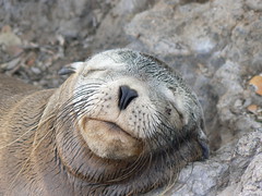
The consequence is that a one meter long iguana will walk next to your shoes as if it could not care less that you were there, the hawk will let you take all the pictures you need before it goes off for hunting baby turtles, the flamingoes will dance few meters from you trying to catch their shrimps from which they get their pink color, the albatrosses will do their unique mating ritual as if you had paid them to do a show for you and the sea lions will play with you in the water every time you go for a swim. This is a place where animals and humans are actually living side by side. As a human being you can’t help feeling blessed. This is a very special place on earth.

Our boat was a huge catamaran. We were 10-12 passengers, 10 crew members and one guide. The itinerary meant some long sail trips visiting 9 different islands. Here are some of our highlights from each stop we made on the way:

Santa Cruz
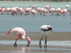
For more than half an hour we sat quiet observing a group of 7 flamingoes tap-dancing in the water of a lagoon in their search for food (mainly shrimps) if they weren’t taking a nap on one leg with their head under a wing. Warm and cozy - that’s how they like to sleep. They got really close to us. Very magical start of our trip.

Rápida
Our first snorkeling experience at the Galapagos was a real treat. Two small fur seals swam few meters from us, a sea lion stared us in our eyes and played with us for what felt like minutes, a couple of huge Eagle-spotted Rays swam underneath us among the Kings Angel fish and the Parrot fish. A green sea turtle passed by us.
Biggest moment though was when a 1,5 meter white tipped reef shark came pretty close to us! A real shark! Imagine!!!

Bartolomé – snorkeling around the Pinnacle Rock
Another great snorkeling point. Few meters from us swam a couple of cute little penguins (the only type of penguins on the Northern Hemisphere). We also met two different kind of Rays and the playful sea lions as always. They have a tendency to act like torpedoes heading straight for you, for in the last second to make a u-turn.

Fernandinha - Punta Espinoza
Waking up early after a rough night at sea, we went to the sundeck to spot for dolphins and whales. Far away in the horizon we spotted the big splash of water from a whale. Another passenger spotted a dolphin. That’s all… well if you don’t take into consideration the animal life around the boat: Very near we kept seeing giant sea turtles breathing air in the surface, the sea lions played with the small fish, the flightless cormorants did amazing dives for food and even a penguin passed by. The Frigate birds was watching us from above. What a great way to wake up :-)

When we went ashore another great view greeted us. Hundreds of marine iguanas sunbathing on the black lava rocks. They are ugly but harmless – if you succeed in avoiding their salty spit. We also met a sea lion mummy and her few minutes old puppy – time stood still, as we sat down watching the mummy nurturing the puppy getting used to the World.
Main attraction on the Island though, was the Flightless Cormorants. Cormorants live in various parts of the world, but it is only at the Galapagos they have lost their ability to fly and instead have developed great diving skills. Their feathers though are not made for the water, so every time they have been taken a swim they have to stand in the sun with open wings, drying them…

Isla Isabela – Urbina Bay
Close-up with the huge yellow land iguanas habiting the island. They are impressive animals. You find land iguanas on several of the Galapagos Islands, but they are all different subspecies whom had spend millions of years adjusting to the specific environment characteristic for that specific island they once landed at, therefore they look very different on each island, and Isla Isabela is the only place where you find the big yellow ones.

Plaza Sul
Plaza Sul is a small Island full of land iguanas and sea lions, covering the beach and the rocks all looking really lazy.
The Island also has a huge cliff where we had our first close-ups with the sea birds: The funny looking Nasca boobies – or the even funnier looking Blue footed boobies (they really do have blue feet), Huge brown pelicans, lava-gulls who have red eyes and can see at night, and we also passed a red-billed tropical bird lying on its nest made in a small cave of rocks…way too small to cover its looong tail.
The walk among the seabirds got a sudden twist when our guide screamed: “Splash! Out at Sea!” We all turned around and could see a whale with her baby calf somewhere out there. We took a quick vote and decided to run for the boats to see if we could get a closer look.
On board at the Catamaran everybody went with their binoculars to the sun deck to help the captain spot the whales. 20 minutes later we were really close and could watch the humpback whale mummy teaching the baby ‘how to throw the whole body over the surface’ and ‘how to wave at tourists’. A great finale to a great day.

Santa Fé
Another swam of Land iguanas greeted us at this island. This subspecies was really big and fat!
As always the beach was covered with sea lions. These sea lions definitely made a clever choice not swimming today since the water near the beach was full of hordes of sharks hoping to catch a sea lion puppy for lunch. Incredible.

San Cristobal
After five days on the sea it was time to change some of the passengers (some people only go for a 4 or 5 day cruise). That meant time for us to hang around in a small touristy village and also time to visit the Interpretation Center explaining the Galapagos Islands history and everyday life. Interesting, - but not as cool as real contact with the animals ;-)

Isla Las Lobos
In the afternoon we had a great boat ride close to the nests of some seabirds. We saw the famous Great Frigate bird sitting on top of a tree with an inflated scarlet pouch like a balloon, hoping to attract a female to mate up with.
Highligth of the day also counted a Blue footed boobie baby sitting in its nest, looking cute in its very fluffy white outfit!

Española
At Española we had some really cool close-ups with the seabirds. The cliffs are covered with Nasca boobies and Blue footed boobies. The Nasca boobies where whistling at each other while they threw their wings back. Their special way of attracting a mate.
And best of all: The waved albatrosses. At this time of the year the Albatrosses reencounter their beloved one and that looks really funny. Impossible to explain…but it includes the sound of opening a wine bottle, sword fighting and clapping with the beaks and lots of kisses. Not even Broadway would be able to present a better show.

We also got close to the Galapagos hawk, the only predator at the Galapagos. It sat quiet in the top of a tree, looking for food…or funny looking tourists.

Again, our guide saw a big SPLASH out at sea, and again the hunt for getting close to the whales started, but this time in our small panga boats, which turned out to be a big adventure, since the waves just got bigger and bigger, and we just got smaller and smaller. When the guide gave up finding the whales, it was with great relief that we went back to the boat, where we all smiled at our fortune of still being alive…

Floreana
The most extraordinary experience on Floreana Island was to stand with several sting rays around our feet in the low water at the beach. We got one instruction, be careful of not stepping on them, or they will sting. Apparently the Australians instructions where not as good…

The snorkeling of the day was at the Devils Crown, that offered numerous tropical fish, but the 10 cm. close encounter Barbara had with a big sea turtle was the highlight! If it hadn’t dived, the strong current would have given Barbara a nose kiss with the turtle. Another magic moment at the Galapagos.

The final tour brought us to the oldest post office in the world, which consists of a barrel where the sailors leave their mail to be picked up by others who are heading home. It actually still works today! We are bringing home a postcard left by a couple of Danish children living in Hadsten.

A really great trip which we will treasure in our memory for a very long time. All the wonderful daily encounters we had with the animals, the superb service we got on the boat, the fresh air that always embraced us – and the really nice feeling of having a base, which was a nice contrast to our ‘normal’ backpacker life. Who would have imagined that we would find our most solid base at sea!

Now several days after being back on mainland, Barbara still have the sensation of being on sea…but as the guide said “Just enjoy the ride as long as it lasts – it’s a nice ride!”

P.S. Henrik actually got kissed by a few months old sea lion puppy. Imagine that!

Friday, September 15, 2006

The Devils Nose and Cuenca


Down the Devils Nose
Originally uploaded by Henrik & Barbara.
The train ride from Riobamba to Alausi via the Devils Nose was extraordinary. The railroad is a masterpiece in engineering science with the extremely steep decline at the Devils Nose, and with a mountain which is nothing but a solid rock…
We spend five hours on the roof of a train with a beautiful view to the Andean landscape (along with about 200 other gringos who, like us, had gone to Riobamba only because of the famous train ride…). Along the track we were greeted by numerous farmers and kids, primarily Indians. It was a good feeling to see the enthusiasm of the locals towards us. It was a great feeling to pass the enormous heights of the Andes.
Five hours did seem a little long because we spend the first 2-3 hours in cold weather (had to buy lama-gloves to keep the cold on a distance) but the last couple of hours in warm weather with the magnificent view, definitely made it worth the effort…

From Alausi we went to Cuenca. Cuenca has a reputation of being the most beautiful city in Ecuador. We are convinced! The city has a great historical centre, and lots of nice squares, where music is being played to create a nice calm environment – a great spot to observe the local life. The colonial architecture of the buildings and the 80 churches in Cuenca actually makes you feel like being in the southern part of Europe. It is a very clean and inviting city. We did not do much – except for lots of wandering in the historical centre in great sunny weather, which was a good contrast to the cold hours on the roof top of the train ride, and we really enjoyed being in a place with a great variety of food like Columbian pancakes and Mexican tacos, in contrast to the more common chicken and rice. For sure we have enjoyed our time in Cuenca!

Cuenca is also known for the so-called “Panama hats”, at least this is the name for the hats in Europe and the States, but you will offend any Ecuadorian if you used that name. The “Panama hats” are Ecuadorian and has only been named Panama hats because of all the Ecuadorian labour that went to Panama about 100 years ago to help the construction of the canal, where the hat became famous.
A first I (Henrik) thought the idea of buying one of these hats where quite foolish, I would probably never wear it… But learning about the history (which has been known since the Spanish conquest in the 16th century) and the craftsmanship behind, made me change my mind, and when I was confronted with a 70 years old active manufacturer who had made these hats since he was 6 years old, I had to surrender. The hat I bought is maybe not the finest of the finest (which cost from 10.000 US$...), but I will definitely enjoy my Montecristi! :o)
Thinking about the weeks it takes to make the hats, which are made of a special palm that only can be found on the north-western coastline of Ecuador, makes it a special souvenir.

Tomorrow, we will head for Guayaquil and continue on to the Galapagos Islands. Hopefully we will find a boat there, which can bring us on a trip around the islands.